Gonzalo accelerates toward the southern windward islands. Is expected to bring tropical storm conditions to portions of the Islands on Saturday.
——————–
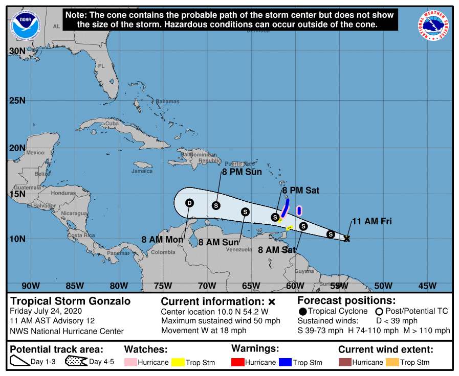
LOCATION…10.0N 54.2W
ABOUT 485 MI…780 KM E OF THE SOUTHERN WINDWARD ISLANDS
MAXIMUM SUSTAINED WINDS…50 MPH…85 KM/H
PRESENT MOVEMENT…W OR 275 DEGREES AT 18 MPH…30 KM/H
MINIMUM CENTRAL PRESSURE…1002 MB…29.59 INCHES
——————–
SUMMARY OF WATCHES AND WARNING IN EFFECT…
A Tropical Storm Warning is in effect for…
* Barbados
* St. Vincent and the Grenadines
* St. Lucia
A Hurricane Watch is in effect for…
* Barbados
* St. Vincent and the Grenadines
A Tropical Storm Watch is in effect for…
* Tobago
* Grenada and its dependencies
A Tropical Storm Warning means that tropical storm conditions are expected somewhere within the warning area within 36 hours.
A Hurricane Watch means that hurricane conditions are possible within the watch area, in this case within 36 hours.
A Tropical Storm Watch means that tropical storm conditions are possible within the watch area, in this case within 36 hours.
Interests elsewhere in the Windward Islands should monitor the progress of this system.
For storm information specific to your area, please monitor products issued by your national meteorological service.
———————-
DISCUSSION AND OUTLOOK
At 1100 AM AST (1500 UTC), the center of Tropical Storm Gonzalo was located near latitude 10.0 North, longitude 54.2 West. Gonzalo is moving toward the west near 18 mph (30 km/h). A general westward- to west-northwestward motion is expected during the next couple of days. On the forecast track, the center of Gonzalo will approach the southern Windward Islands tonight and then move across the islands on Saturday and over the eastern Caribbean Sea on Sunday.
Maximum sustained winds are near 50 mph (85 km/h) with higher gusts.
There is considerable uncertainty in the intensity forecast, but some strengthening is still possible during the next day or so before Gonzalo reaches the southern Windward Islands. Weakening is expected after Gonzalo moves into the Caribbean Sea, and the cyclone is expected to dissipate by the middle of next week.
Gonzalo is a small tropical cyclone. Tropical-storm-force winds extend outward up to 25 miles (35 km) from the center.
The estimated minimum central pressure is 1002 mb (29.59 inches).
———————-
HAZARDS AFFECTING LAND
Key messages for Gonzalo can be found in the Tropical Cyclone Discussion under AWIPS header MIATCDAT2 and WMO header WTNT42 KNHC.
WIND: Tropical storm conditions are expected within portions of the Tropical Storm Warning area on Saturday. Hurricane conditions are possible on Saturday within the Hurricane Watch area.
RAINFALL: Gonzalo is expected to produce total rain accumulations of 2 to 5 inches, with isolated maximum amounts of 8 inches in Barbados and the Windward Islands through Sunday night. Gonzalo is also expected to produce total rain accumulations of 2 to 4 inches in Trinidad and Tobago as well as 1 to 2 inches over northeastern Venezuela. Rainfall in Barbados and the Windward Islands could lead to life-threatening flash floods.
Source: National Hurricane Center and Central Pacific Hurricane Center