WARNINGS AND WATCHES ISSUED FOR A PORTION OF THE YUCATAN PENINSULA…
NHC is issuing advisories on newly formed Tropical Depression Twenty-Five. The government of Mexico has issued a Tropical Storm Warning for the Yucatan Peninsula of Mexico from Punta Herrero to Cabo Catoche, and a Tropical Storm Watch south of Punta Herrero to Puerto Costa Maya and west of Cabo Catoche to Dzilam. Tropical storm conditions are expected within the Tropical Storm Warning area by early Saturday, and are possible within the Tropical Storm Watch area on Saturday and Sunday.
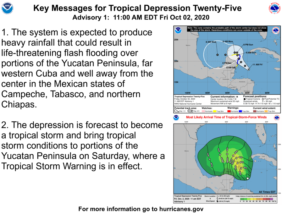
At 11 a.m. EDT, the center of Tropical Depression Twenty-Five was located over the northwestern Caribbean Sea about 220 miles (355 km) southeast of Cozumel, Mexico. It’s moving toward the northwest near 9 mph (15 km/h), and a gradual turn toward the north-northwest with a decrease in forward speed is expected during the next couple of days. On the forecast track, the center of the tropical cyclone should be near the northeastern Yucatan Peninsula on Saturday.
Maximum sustained winds are near 35 mph (55 km/h) with higher gusts. Some strengthening is forecast to take place, and the depression is expected to become a tropical storm by Saturday morning. When that occurs, it will be named Gamma.
The depression is expected to produce rainfall of 4 to 8 inches, with isolated maximum amounts of 12 inches, in portions of the Yucatan Peninsula and far western Cuba. A separate area of significant rain is expected to develop well away from the center in the Mexican states of Campeche, Tabasco, and northern Chiapas, with rainfall of 8 to 12 inches and isolated maximum amounts of 20 inches. This rainfall may produce life-threatening flash floods and mudslides. Rainfall of 1 to 3 inches with maximum amounts of 5 inches is expected in the Bay Islands of Honduras.
The next complete advisory will be issued by NHC at 5 p.m. EDT with an intermediate advisory at 2 p.m. EDT – www.hurricanes.gov
There is a tropical wave over the eastern Caribbean Sea that is producing a large area of disorganized showers and thunderstorms, accompanied by locally heavy rainfall and gusty winds. This wave is forecast to move westward at 15 to 20 mph during the next several days, and environmental conditions could become a little more conducive for development when the system is over the central or western Caribbean Sea early next week. It has a near zero chance of formation during the next 48 hours and a low (30 percent) chance during the next five days. – www.hurricanes.gov