Satellite imagery indicates that Elsa has become better organized, and radar data from Barbados and Martinique have shown attempts at eye formation. The formative northern eyewall passed over Barbados near 11-12Z, and hurricane-force winds were reported there at that time. The initial intensity is set at 65 kt based on those data. It should be noted that reports from an Air Force Reserve Hurricane Hunter aircraft suggest that the circulation is not well-developed at 700 mb, possible due to the rapid forward speed.
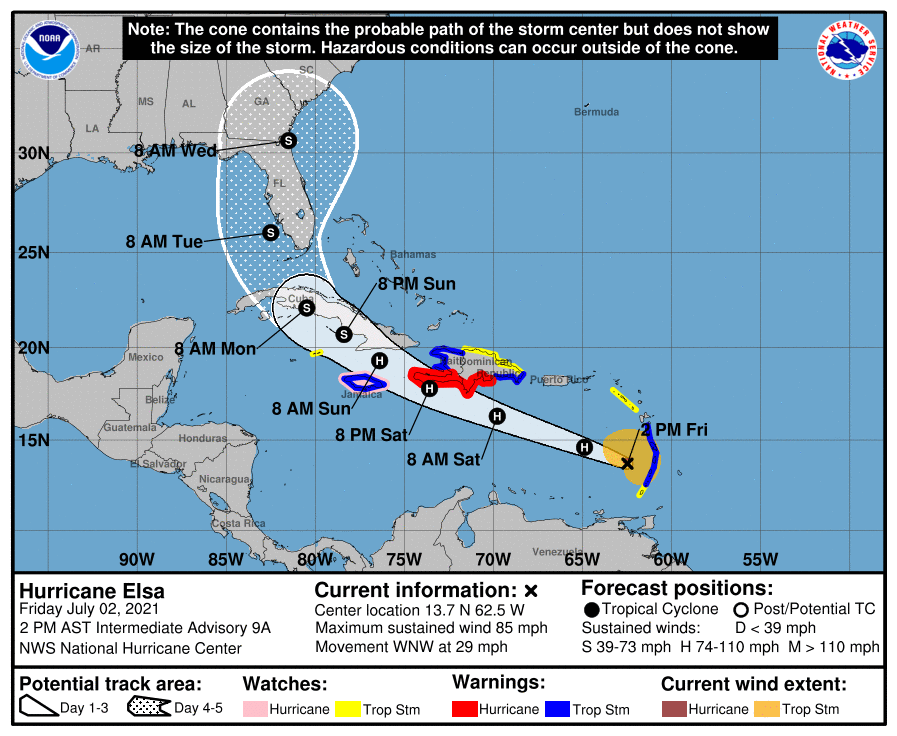
The initial motion is 290/25. There is little change to the forecast track or the forecast guidance since the last advisory. The guidance is in good agreement on a rapid west-northwestward notion to near the south coast of the Dominican Republic by 36 hr. After that, the general consensus is that Elsa should turn northward by 96 h through a weakness in the subtropical ridge created by a mid-latitude trough. However, the guidance is quite divergent around this consensus, with possible tracks ranging from a west-northwestward motion through the Yucatan Channel or western Cuba to a northward motion through the Bahamas. Thus, the latter portion of the track forecast remains low confidence.
The intensity forecast calls for a little more strengthening during the next 36 has Elsa moves through an environment of light westerly shear. After that, land interaction, along with less favorable upper-level winds over the Gulf of Mexico, is likely to cause weakening. The new NHC intensity forecast shows major adjustments from the previous forecasts based primarily on the initial intensity.
It should be noted that the average NHC track errors are 175 miles and 200 miles at days 4 and 5, respectively. Given the larger-than-normal uncertainty and because hazards will extend well away from the center of the storm, users are urged to not focus on the exact forecast points.
Key Messages:
Hurricane conditions are expected in the Hurricane Warning area in the Windward Islands for the next few hours. Tropical storm conditions are expected in other portions of the Windward and Leeward Islands. Hurricane conditions are expected in the Hurricane Warning area in Haiti on Saturday. Tropical storm conditions are expected with hurricane conditions possible along the southern coast of the Dominican Republic and in Jamaica.
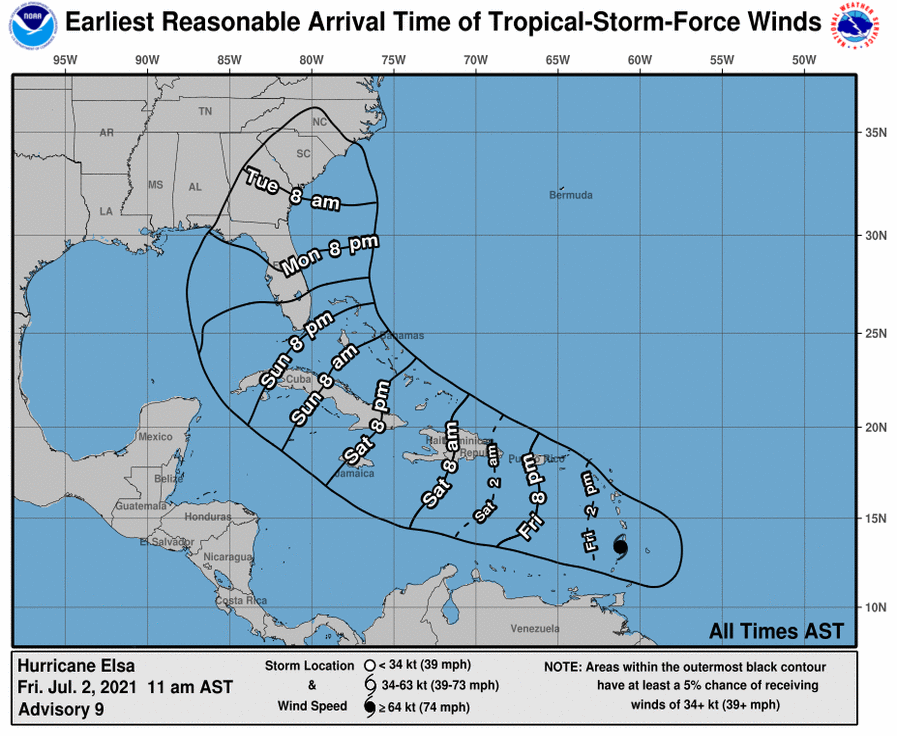
Heavy rainfall from Elsa will move quickly across the Windward and southern Leeward Islands today, including Barbados. Outer rain bands will impact Puerto Rico late today into Saturday, and southern Hispaniola and Jamaica Saturday into Sunday. Flooding and mudslides are possible.
There is an increasing risk of strong winds, storm surge and rainfall impacts in portions of Cuba this weekend and early next week, with impacts also possible in the Turks and Caicos and the Bahamas. Interests in these areas should monitor Elsa’s progress and updates to the forecast.
There is a risk of storm surge, wind, and rainfall impacts in the Florida Keys and portions of the Florida Peninsula early next week. However, the forecast uncertainty remains larger than usual due to Elsa’s potential interaction with the Greater Antilles this weekend. Interests in Florida should monitor Elsa’s progress and updates to the forecast.
FORECAST POSITIONS AND MAX WINDS
INIT 02/1500Z 13.4N 61.2W 65 KT 75 MPH
12H 03/0000Z 14.6N 64.9W 70 KT 80 MPH
24H 03/1200Z 16.3N 69.8W 70 KT 80 MPH
36H 04/0000Z 17.8N 73.6W 70 KT 80 MPH
48H 04/1200Z 19.3N 76.4W 65 KT 75 MPH
60H 05/0000Z 20.7N 78.4W 55 KT 65 MPH
72H 05/1200Z 22.1N 80.5W 55 KT 65 MPH…INLAND
96H 06/1200Z 26.0N 82.5W 55 KT 65 MPH…OVER WATER
120H 07/1200Z 30.6N 81.5W 40 KT 45 MPH…INLAND
Source: NOAA/NHC